TerraScribe
TerraScribeTM
TerraScribe triangulates the relative position of selected features within geo--positioned stereo images and transfers the location and attribute data into the global coordinate system. This allows users to determine the GPS coordinates of any feature captured by the camera stereo pairs and perform remote inventory, condition and analysis of the Right of Way (ROW) without ever leaving the office.
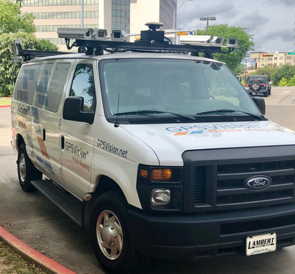
TerraScribe provides all the software tools and interfaces to extract mapping, inventory, and condition data from the stereo pair images collected with the GPSVision TM system. The Global Positioning System and other satellite systems, along with Distance Measurement Instruments (DMI) and Inertial Navigation Units (IMU) are used in combination with pairs of high-speed digital optical and infrared cameras and other road sensing point and line laser devices for easy mobile mapping of the transportation ROW infrastructure.
Digital information such as image pairs and roughness, rutting and pavement distress are collected at highway speeds at operator-defined intervals, and tagged with position and attribute data. These geo-referenced digital sensor data and images are then viewed with Terrascribe software and integrated GPSVision TM infrastructure management software.

Product Strengths:
- Faster, more accurate and more cost-effective than other data collection methods that still meet the required ASTM PCI data collection criteria.
- Accurate location data positioned with a horizontal accuracy of one meter at distances of up to 20 meters into the image.
- Easily creates maps and can generate files for all major mapping/GIS systems.
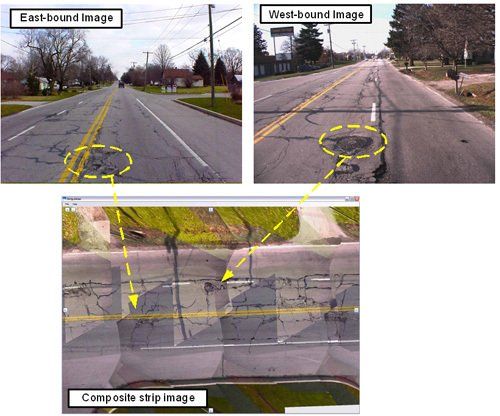
- Provides a frame by frame visual representation of your exact route, just as if you were driving it.
- Links extracted Feature locations and attributes to road segment IDs.
- Collected images can be used repeatedly to collect additional information that may or may not have been considered during the initial planed survey.
Key Features:
Includes all needed image manipulation tools for viewing features from all angles and views.
- Versatile editing tools to customize the project files for any type of features.
- Virtual viewing of entire routes with the capability to interact with features for locating, measuring, recording data.
- Able to handle massive datasets for fast production processing.
How this product is different from competitor products?
- Unique stereo imaging approach.
- Delivering collected data in GPS based editing for easier and faster processing
- Information in a useful multi-purposes format.
- Pioneering work in data interface with asset management systems.
- Fast and Accurate
- Stereo GPS measurements combined with Terrestrial Ortho's accuracy.
Repeatability
- High resolution reusable imagery.
- Data can be visualized on the images to determine what has been inspected.
- Transfer of visual inventory between surveys.
- Old distresses/repairs/renovations overlaid over new images.
Visibility
- Multiple views-perspective, oblique and plan.
- Multi-directional views-from and to directions.
- Exact elevation distress measurements.
Flexibility
- GPS imagery can be used to collect other ROW data.
- Virtually visit an area documented by TerraScribe.
- Easier & safer for in-house and consultant personnel.
Cost Benefit
- Data is versatile and can be reused for a multitude of purposes